
Suchiate River
River in Guatemala
The Suchiate River (Spanish: Río Suchiate, Spanish pronunciation: [suˈtʃjate]) is a river that marks the southwesternmost part of the border between Mexico (state of Chiapas) and Guatemala (department of San Marcos). From its sources on the southern slopes of the Tacaná volcano in the Sierra Madre range of Guatemala, the 161 km (100 mi) long river flows in a south-southwesterly direction to the border with Mexico at Unión Juárez (15.070549°N 92.059722°W / 15.070549; -92.059722 (Río Suchiate Source2)), past the border towns Talismán and El Car...
Nº Q1948509 ★★
Uncommon · Places
Suchiate River
River in Guatemala
The Suchiate River (Spanish: Río Suchiate, Spanish pronunciation: [suˈtʃjate]) is a river that marks the southwesternmost part of the border between Mexico (state of Chiapas) and Guatemala (department of San Marcos). From its sources on the southern slopes of the Tacaná volcano in the Sierra Madre range of Guatemala, the 161 km (100 mi) long river flows in a south-southwesterly direction to the border with Mexico at Unión Juárez (15.070549°N 92.059722°W / 15.070549; -92.059722 (Río Suchiate Source2)), past the border towns Talismán and El Car...
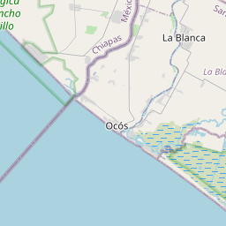
On the map
Last price
—
Floor price
—
7-day median
—
30-day sales
0
30-day range
—
In circulation
0
Price history
median
low – high
sales
No sales in this period
Show table
| Date | median | Low | High | sales |
|---|
Sales history
- Last sale
- —
- 30-day average
- —
- 30-day low
- —
- 30-day high
- —
- Sales 7d
- 0
- Sales 30d
- 0
No sales yet.
Anonymous sales: no buyer or seller shown. Figures count player-to-player sales only.
From Wikipedia
The Suchiate River (Spanish: Río Suchiate, Spanish pronunciation: [suˈtʃjate]) is a river that marks the southwesternmost part of the border between Mexico (state of Chiapas) and Guatemala (department of San Marcos). From its sources on the southern slopes of the Tacaná volcano in the Sierra Madre range of Guatemala, the 161 km (100 mi) long river flows in a south-southwesterly direction to the border with Mexico at Unión Juárez (15.070549°N 92.059722°W / 15.070549; -92.059722 (Río Suchiate Source2)), past the border towns Talismán and El Carmen, and then Ciudad Tecún Umán and Ciudad Hidalgo (Chiapas) further downstream, where the Puente Rodolfo Robles and a railway bridge cross the river, and on to the Pacific Ocean. Its name comes from the Nahuatl name Xochiatl meaning "flower-water". The pre-Columbian archaeological site of Izapa lies along the river.
Text: Wikipédia, CC BY-SA 4.0. · Image: Fernando Reyes (CC BY-SA 2.0) ·
Related cards
-

Suchiate
Municipality in the State of Chiapas, Mexico
Nº Q1953211 ★
Not listed
-

Hidrografía de Guatemala
Nº Q5897162 ★
Not listed
-

Suchitan
Mountain in Guatemala
Nº Q3065113 ★★
Not listed
-

Paz River
River in southern Guatemala
Nº Q3083598 ★
Not listed
-

Río Sucio
River in El Salvador
Nº Q66103155 ★
Not listed
-

Volcán Tacaná
Volcano between Mexico and Guatemala
Nº Q1752870 ★★★
Not listed