
monte latmo
Mountain range
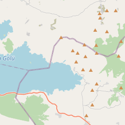
Beşparmak Mountains (Latin: Latmus; Ancient Greek: Λάτμος, romanized: Latmos) are a ridge of many spurs located in the Muğla and Aydın provinces of Turkey, running in an east–west direction along the north shore of the former Latmian Gulf on the coast of Caria, which became part of Hellenised Ionia. The city of Latmus, located on the south slopes of Mount Latmus 25 kilometres (16 mi) east of Miletus, was originally a port on the narrow gulf, as reported by Strabo.
Nº Q854649 ★
Común · Lugares
monte latmo
Mountain range
Beşparmak Mountains (Latin: Latmus; Ancient Greek: Λάτμος, romanized: Latmos) are a ridge of many spurs located in the Muğla and Aydın provinces of Turkey, running in an east–west direction along the north shore of the former Latmian Gulf on the coast of Caria, which became part of Hellenised Ionia. The city of Latmus, located on the south slopes of Mount Latmus 25 kilometres (16 mi) east of Miletus, was originally a port on the narrow gulf, as reported by Strabo.
En el mapa

Último precio
—
Precio mínimo
—
Mediana 7 d
—
Ventas 30 d
0
Rango 30 d
—
En circulación
0
Cotización
mediana
mín – máx
ventas
Sin ventas en el periodo
Ver tabla
| Fecha | mediana | Mín | Máx | ventas |
|---|
Historial de ventas
- Última venta
- —
- Media 30 d
- —
- Mínimo 30 d
- —
- Máximo 30 d
- —
- Ventas 7 d
- 0
- Ventas 30 d
- 0
Aún no hay ventas.
Ventas anónimas: sin comprador ni vendedor. Las cifras solo cuentan ventas entre jugadores.
En Wikipedia
Texto en inglés Aún no hay artículo en tu idioma: extracto en inglés.
Beşparmak Mountains (Latin: Latmus; Ancient Greek: Λάτμος, romanized: Latmos) are a ridge of many spurs located in the Muğla and Aydın provinces of Turkey, running in an east–west direction along the north shore of the former Latmian Gulf on the coast of Caria, which became part of Hellenised Ionia. The city of Latmus, located on the south slopes of Mount Latmus 25 kilometres (16 mi) east of Miletus, was originally a port on the narrow gulf, as reported by Strabo. He also states that Latmus is the same as Mount Phthires in the Catalogue of Trojans. The mouth of the Gulf of Latmus began to fill with sediment from the Maeander (Büyük Menderes) river, which emptied into it, even in classical antiquity. By 300 CE Lake Bafa had formed behind the estuary marshes. It gradually diminished in salinity and would now be fresh water except that canals to the Aegean introduce a saline element. The ecology remains a brackish-water one and the lake has been made a bird sanctuary. Its area of 7 square kilometres (2.7 mi2) with a maximum depth of 25 metres (82 ft) still extends from the base of the west spur of Mount Latmus, although, having lost its port, the ancient medium-sized town of Heraclea ad Latmum has declined in size and facilities to the small village of Kapikiri. Beşparmak looms far beyond Kapikiri to the east for a total distance of about 35 kilometres (22 mi), 5 kilometres (3.1 mi) to 10 kilometres (6.2 mi) wide. It is deeply eroded by various streams into spurs. The spur that can be seen from Kapikiri is one Dağ, or "mountain", but the entire ridge with all the spurs is Dağlar, "mountains", in the sense of "range." The ancient writers generally recognized the western spur over the gulf...
Texto: Wikipedia en inglés, CC BY-SA 4.0. · Imagen: Wolfgang Glock (Public domain) ·
Cartas cercanas

Allahuekber Mountains
Mountain range in northeastern Turkey
Nº Q2359589 ★

Mount Artos
Mountain in Van province, Turkey
Nº Q6018069 ★★★★

Pindo
Macizo montañoso del Epiro, cordillera del norte de Grecia, del sureste de Albania y del sureste de Macedonia, cuya máxima elevación es el monte Smolikas.
Nº Q201582 ★★

Montes Pónticos
Cordillera ubicada en el norte de Turquía
Nº Q519263 ★★

Puerto de Karakórum
Nº Q784798 ★★

Cordillera del Atlas
Sistema montañoso del norte de África
Nº Q130135 ★★★★