
Hoynat Islet
Turkish islet
Hoynat Islet (a.k.a. Perşembe Islet Turkish: Hoynat Adası) is a Turkish islet in the Black Sea. Administratively it is a part of Perşembe ilçe (district) of Ordu Province. The distance between the coast and the islet is less than 100 metres (330 ft).
Nº Q28155617 ★★★★
Super rare · Lieux
Hoynat Islet
Turkish islet
Hoynat Islet (a.k.a. Perşembe Islet Turkish: Hoynat Adası) is a Turkish islet in the Black Sea. Administratively it is a part of Perşembe ilçe (district) of Ordu Province. The distance between the coast and the islet is less than 100 metres (330 ft).
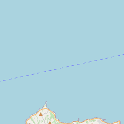
Sur la carte


Dernier prix
—
Prix plancher
—
Médiane 7 j
—
Ventes 30 j
0
Fourchette 30 j
—
En circulation
0
Cours
médiane
min – max
ventes
Aucune vente sur la période
Voir le tableau
| Date | médiane | Min | Max | ventes |
|---|
Historique des ventes
- Dernière vente
- —
- Moyenne 30 j
- —
- Plus bas 30 j
- —
- Plus haut 30 j
- —
- Ventes 7 j
- 0
- Ventes 30 j
- 0
Aucune vente pour l'instant.
Ventes anonymes : ni acheteur ni vendeur. Les chiffres ne comptent que les ventes entre joueurs.
Sur Wikipédia
Texte en anglais Pas encore d'article dans ta langue : extrait en anglais.
Hoynat Islet (a.k.a. Perşembe Islet Turkish: Hoynat Adası) is a Turkish islet in the Black Sea. Administratively it is a part of Perşembe ilçe (district) of Ordu Province. The distance between the coast and the islet is less than 100 metres (330 ft). The total area of the islet is about 700 square metres (7,500 sq ft). Historically the uninhabited islet was a hideout and storage location of the sailors. Now the island is known as the main reproduction area of the European shags in Turkey.
Texte : Wikipédia en anglais, CC BY-SA 4.0. · Image : Asımcaga (CC BY-SA 4.0) ·


